The Centrality of Central Park to NYC

First post participating in NaBloPoMo (National Blog Posting Month) in which I feature my first encounter with Central Park in New York City.

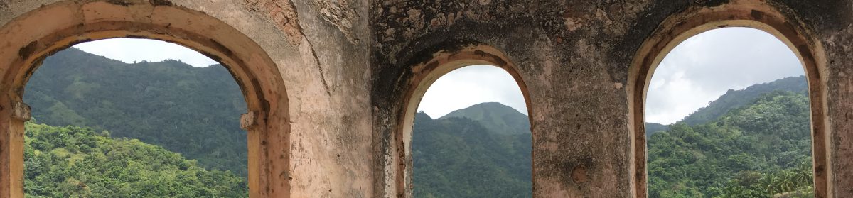
Well, it’s November 1 and I’ve decided to take part in NaBloPoMo (National Blog Posting Month). That means I’ll post something on my blog every single day this month. Thousands of people are participating in this event all over the world so the ‘National’ should really be changed to ‘International’ resulting in InBloPoMo. But at the moment it remains the blogging counterpart of NaNoWriMo (National Novel Writing Month) during which hundreds of thousands of would-be novelists churn out 50,000 words during the month of November. Well, i guess they haven’t heard of the demise of the novel…

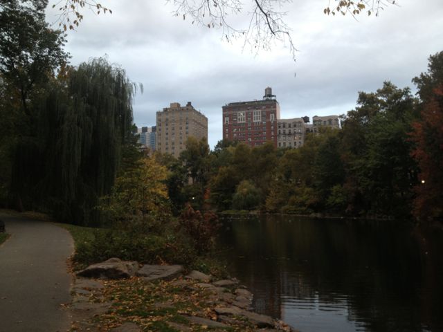
So I was in New York City last month for about 9 days and found myself staying one short block from Central Park. Before reaching the city I had had ambitions of walking in the Park every single day of the precious 3 days at that particular address. No such thing happened and I found myself hurriedly getting a walk in on the very last day. What surprised me was that even though it was the end of October very few trees had changed to the traditional autumn colours of yellow, orange and red. Was this another sign of the creeping climate change we’ve all been noticing recently?

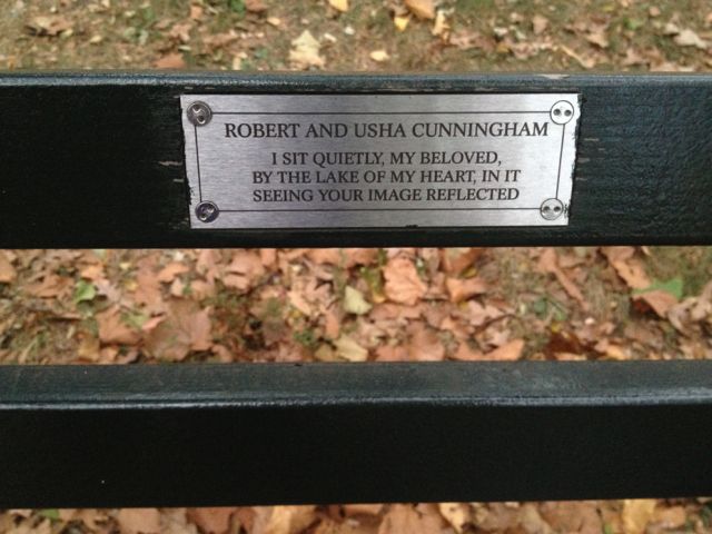
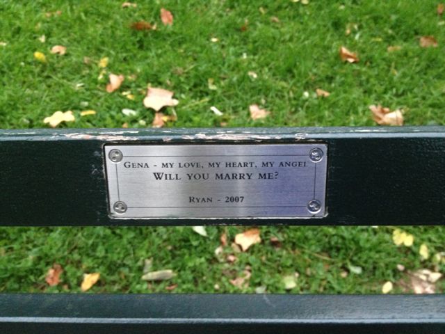
The apartment I was staying in was at 102nd st very close to the 103d st entrance to the Park. There’s a lovely duck pond there with benches sprinkled here and there. What I hadn’t expected were the little plaques on each bench evidently placed there by the individuals or families who had paid for the particular bench. I’ll post some of the photos I took below:

CentralPark01 CentralPark02 CentralPark03 CentralPark04 CentralPark05 CentralPark06 CentralPark07 CentralPark08 CentralPark09 CentralPark10 CentralPark11

And soon after getting back to Kingston I came across the article below which I found alarming considering that Central Park in effect constitutes the lungs of the city…are the proposed skyscrapers akin to invasive cancerous growths that will eventually cause the demise of this treasure?

Luxury Skyscraper Shadows Are Devouring Central Park

http://gothamist.com/2013/10/29/skyscraper_shadows_will_ruin_centra.php

102913shadow.jpg
One57 looms large over Central Park, its shadow resembling an appropriately obscene gesture. (Warren St. John)

The city’s parks are among the few empty spaces protected from New York developers. No parking garages will ever trample Central Park’s Sheep Meadow and no high-rise Walmart’s will ever raze Prospect Park’s Nethermead. But there is one threat to the park’s sanctity that perhaps few people had considered: The Shadows.

It’s not a weird hypothetical sprung from the world of sci-fi. Developers are eying the south side of the park as the new home to seven enormous towers which will serve as second and third homes for as-yet-unborn children of gallingly wealthy oil moguls around the world. The towers, nicknamed Billionaire’s Row, will stand as tall as 1,424 feet, and the shadows they will cast over the park will serve as chilling reminders that their owners are probably on a plane destined for Saint-Tropez anyway, and you’re on the ground shivering under their icy umbra. It’s an allegory for your life.

Looming skyscrapers can make a particular difference in the winter months, Michael Kwartler, the president of the Environmental Simulation Center, told Warren St. John, who penned an op-ed in today’s Times on this very issue. At noon on the winter solstice, Kwartler calculates that the building’s shadows will fall half a mile into the park by noon, and up to a mile as the day wears on. “The cumulative effect of these shadows will be to make the park less usable and less pleasant to be in,” Kwartler said.

Hurricane Sandy of the thousand foot windspan…Hang tight everyone!

A note on Hurricane Sandy as she menaces the East Coast of the United States.

The Hope River in spate - Varun Baker photo. Email: varun.baker@gmail.com
The Hope River (Kingston, Jamaica) in spate – Varun Baker photo.

UPDATE! Seven people came to this blog today searching for “hurricane sandy in jamaican patwa”. Can’t tell you how happy that makes me.

SANDY. A hurricane event with a windspan so broad (1000 miles wide) she’s menacing the United States from New York and the East Coast all the way to Chicago. And this after ravaging us in the Caribbean from Jamaica to the Bahamas, through Cuba and Haiti. People don’t understand how a Category 1 hurricane can do so much damage. Satellite shots make it look as humdrum as buttermilk seething in a giant churn but Sandy is dangerous because she’s slow moving and large–as i said her windspan is unusually wide, and she’s adept at the slow creep. So though not packing as much power as a Cat 4 or 5 storm usually does over a much narrower radius Sandy’s still deadly because of the water she brings with her. She dumps so much rain on affected areas as she creeps along in slowmo that the earth gets sodden and trees and poles are no longer securely anchored toppling over once the wind starts plucking at them. Its the flooding Sandy produces that will be the real threat, especially to people in what are called “low-lying areas” (like the homes in the photos by Varun). Meanwhile the relative height of one’s locality is just coming home to people. As the writer Hari Kunzru (@harikunzru) said on Twitter:

Beginning to appreciate the ‘hill’ part of Clinton Hill. #sandy

The Hope River in spate - Varun Baker photo. Email: varun.baker@gmail.com
Varun Baker photo. http://varunbaker.com/
A view of the coast at Palmyra Rosehall, St James - Hoween Griffiths Photo. Email: h.griffiths@rosehall.com
A view of the coast at Palmyra Rosehall, St James – Hoween Griffiths Photo. Email: h.griffiths@rosehall.com

At any rate that was our experience with Sandy here in Jamaica. A lot of trees went down or were brutally pruned. She seemed to have something against banana plants…people think they’re trees but they’re not, they’re large plants…so yes, we’ll have no bananas for the next 6 months because both Portland and St. Mary, the banana parishes, have been devastated.

So good luck to all the folks in the US of A who aren’t used to tropical weather events such as hurricanes…its like a wet tornado i guess. And hopefully by the time Sandy has swept through the East Coast you won’t be emerging into a political cyclone as the Republicans and the Democrats go head to head and Mittens and Big O face off for the big one on November 6. We hope that whichever candidate wins he will take the threat of global warming seriouly. Again i turn to Twitter for some instant wisdom on the matter:

RT @TonyKaron: Sandy’s disruption of electioneering is nature’s poetic rebuke to both candidates for their silence on climate change #fb

PS: Breaking News! As of 8 pm EST it was declared that Sandy is now a post-tropical storm. She has morphed into a cold weather event.

and i eavesdropped on this twitterati convo:

SalmanRushdie's avatar
Salman Rushdie @SalmanRushdie

Lights flickered off/on. Wind crazy.Watching the big old tree out back. It’s a tough New York tree. It can take it. Right, tree? Am I right?

IamDeepaMehta's avatar
Deepa Mehta @IamDeepaMehta

@SalmanRushdie You absolutely are , right that is. Hang tight tree. Hang tight Salman XX

harikunzru's avatar

@IamDeepaMehta @SalmanRushdie having same feelings re tree outside our place in Clinton Hill


and look at this photo posted by @nycarecs
Official Twitter feed of the New York City Amateur Radio Emergency Communications Service (NYC-ARECS)

AN OCEAN ON NY’S LOWER EAST SIDE. Never happened ever like this. #sandy #nyc via @nycarecs

Hang tight everyone!

Got this from NYTimes.com.
“Sea water flooded the Ground Zero construction site.”
Photo: John Minchillo/Associated Press

oh my various gods! will the US Presidential elections have to be postponed…? at this rate? things are deteriorating rapidly in NYC, don’t think they can recover by Nov 6…

%d bloggers like this: